Unpacking the Data Center Backlash with Jasmine Sun
October 8, 2026 • 8:00 – 9:00 am EDT
Hosted by Wadhwani AI Center

Photo: Zhang Jiansong/Xinhua via Getty Images
Authoritarian states are increasingly targeting the undersea infrastructure that connects the United States with its allies and partners. From Western Europe to the waters surrounding Taiwan, Russia and the People’s Republic of China (PRC) are waging a hybrid war campaign—one that incorporates gray zone operations below the threshold of armed conflict to shape favorable battlespace and narratives. Central to their approach are state-owned civilian academic vessels that are “dual-use.” Such civilian vessels provide plausible deniability while enabling state-level intelligence, surveillance, and reconnaissance (ISR). To assess the extent of this strategy, the Futures Lab compared Chinese research vessel behavior against a sample of 47 other nations, including the United States and Russia. Analysis by the Futures Lab of over 200 research vessels reveals that PRC research vessels spend a statistically significantly larger share of time on the high seas—outside of international legal restrictions—near critical infrastructure. Moreover, for four out of the last five years (January 1, 2020–December 9, 2025), PRC research vessels appear in the top 20th percentile of vessels active on the high seas near critical infrastructure, with a notable increase in 2024. Put simply, the Chinese Communist Party (CCP) is ramping up its surveillance of the very undersea infrastructure that it would undoubtedly seek to sabotage in a future conflict.
The PRC’s dual-use research fleet poses a particular strategic risk to U.S.-allied communications and naval operations in the first island chain. Undersea fiber-optic cables carry an estimated 99 percent of data internationally, and daily transactions are worth an estimated $22.4 trillion. This level of transnational communication cannot be replaced with satellite communication in the event of degradation by the PRC due to significant bandwidth differences between fiber-optic and space-based communications systems. Moreover, any serious disruption, accidental or intentional, would likely have cascading effects due largely to the wide time horizon associated with repairs, ranging from days to months. The impact of delays, however, is of growing concern, as repair delays are steadily increasing due to a lack of repair ships and a complicated, often international or opaque, permitting process. Furthermore, timely repairs could be jeopardized by the trading speed of high-risk vendor service and the risks of wartime safe passages.
Put simply, the Chinese Communist Party is ramping up its surveillance of the very undersea infrastructure that it would undoubtedly seek to sabotage in a future conflict.
Dual-use vessels provide the PRC with more than simple information about or access to fiber-optic cables. Surveys of the ocean floor are examples of intelligence preparation of the operational environment (IPOE), the analytical process used to provide predictive intelligence about an adversary’s probable intent and likely future actions. U.S. Navy officials have publicly testified that the collection of temperature, salinity, and current data enables the People’s Liberation Army Navy (PLAN) to optimize sonar performance and support persistent long-range underwater surveillance. Public reporting has documented Chinese-flagged research vessels equipped with seabed-mapping systems such as multibeam echo sounders that can be used to map underwater terrain to support military operations. These dual-use survey vessels were also observed via automatic identification system (AIS) traveling in grid-like “lawnmower” patterns associated with bathymetric surveying to create accurate maps of the seafloor. In addition, PRC survey missions have deployed underwater gliders and profiling floats that extend data collection across wide areas of the ocean. Europe faces a similar threat in its oceans from modern Russian research vessels, which are equipped with proton magnetometers that can identify metallic seabed objects including pipelines, anchors, and wrecks. Together, these collection methods could provide advanced force options that support future military operations ranging from gray zone harassment to sabotage.
Gray zone research activities are carried out by both Russia and China, but to situate the analysis in the Indo-Pacific, the focus of this white paper is the PRC. To analyze PRC survey vessel activity, the Futures Lab leveraged AIS tracking data and spatial layers from General Atomics’ Optix platform for statistical analysis. The research team started by curating a dataset of more than 200 research vessels, tracking their movements from January 1, 2020, to December 9, 2025. In addition, the team created a classification framework to label persistent ambiguous activity near subsea infrastructure on the high seas (Table A2).
Applying statistical analysis, as detailed in Appendix A, the team found that PRC-flagged ships spend significantly more time on the high seas compared to vessels registered to the United States, Russia, and 45 other nations. Additionally, an unexpected finding emerged—PRC research vessel activity near subsea infrastructure increased sharply in 2024. Two PRC-vessel case studies—the Xiang Yang Hong 06 (向陽紅06) and the Ke Xue (科學號)—illustrate how this statistical pattern appears in practice. Both vessels ranked among the most active PRC platforms within the larger dataset and conducted repeated, survey-like movements near strategically significant cable systems on the high seas, including a likely ISR mission on their “no limits” partner, Russia, in the summer of 2024.
Protecting critical undersea infrastructure on the high seas will require the United States and its allies and partners to establish a more credible deterrent at sea. This approach should be anchored on three core goals. First, they should strengthen maritime domain awareness (MDA) and publish evidence of suspicious activity via an international counter–gray zone forum. Second, U.S. allies and partners should form a multilateral coalition of maritime law enforcement that jointly patrols near critical infrastructure to deter gray zone activities on the high seas. Third, stakeholders should invest in regional repair hubs and multinational cable repair fleets. Together, these measures would improve deterrence by detection and exposure, increase MDA, and build resilience against threats to critical underwater infrastructure.
Gray zone activities and campaigns represent actions below the threshold of conflict covering everything from cyber, mis/dis/malinformation, and maritime militia harassment to unattributed acts of sabotage. These operations achieve limited goals without the risk of escalation, but the objectives and outcomes vary. The PRC wages gray zone campaigns to expand territorial claims in the South China Sea, India, and Taiwan. The PRC’s tactics include creating dual-use infrastructure for forward deployment of forces via public rail systems, establishing villages in disputed areas along the border with India, and building dam infrastructure in Tibet to control water flows to downstream countries in the Mekong region. The PRC is also active in building artificial islands and directing its maritime militia to illegally fish, damage coral reefs, coordinate maneuvers, loiter near Taiwan, and sabotage subsea critical infrastructure.
In contrast, Russia conducts gray zone campaigns in Europe to test the strength of NATO, undermine European unity, and pursue territorial expansion. Moscow’s efforts range from sending drones into EU members’ airspace and financing sabotage groups to using energy coercion against EU members. The combined effect is a mix of coercive signaling and setting conditions for future operations.
Modern gray zone campaigns by the PRC and Russia “advance without attacking,” seeking limited objectives without triggering dangerous escalation spirals. One gray zone activity less scrutinized in public and academic discourse is the use of scientific research vessels—similar to the vessel depicted in the image below—to scan the seabed and gather oceanography data that can be repurposed for military planning.
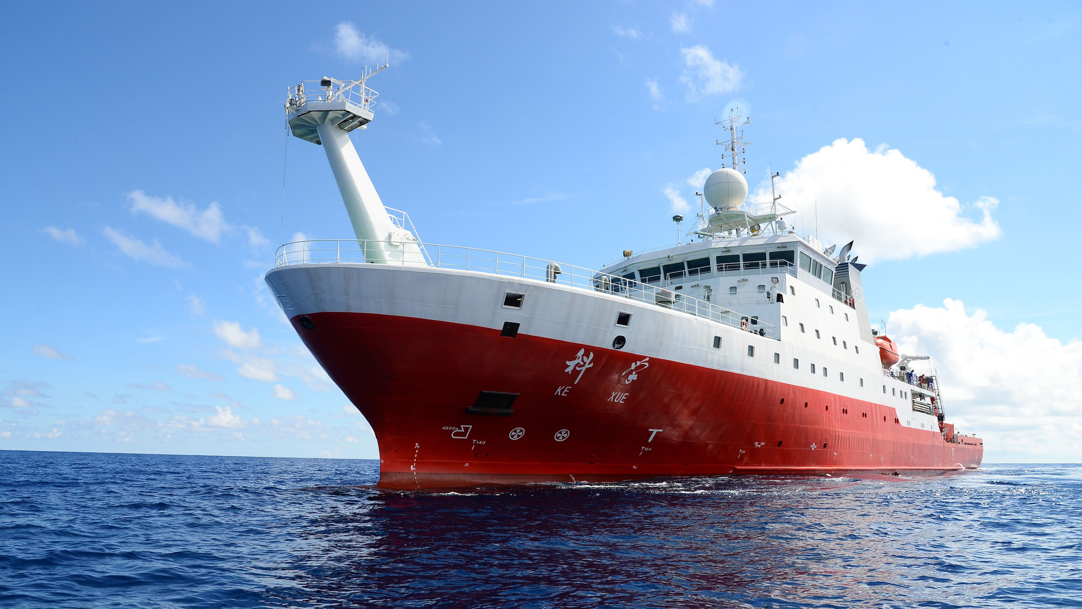
China’s Ke Xue research vessel. | Photo: Xinhua/Zhang Xudong via Getty Images
The CCP has leveraged naval research vessels to enhance military capability for decades. Under the PRC’s military-civil fusion doctrine, Beijing carries out civilian marine research and national security–oriented undersea intelligence collection. As early as 2016, the PLA stated that they would “leverage resources in marine resource surveys, deep-sea exploration, and oceangoing transport, to enhance the mobilization of maritime and undersea combat forces . . . and harness the mobilization capabilities of emerging domains.” As such, the organizational structure of Chinese marine research institutes falls under CCP leadership and policy. Moreover, and significantly for this report, marine institute survey vessels are crewed by personnel that receive military training. In practice, PRC-flagged research vessels are reported to be mapping parts of the Pacific, Indian, and Arctic Oceans, as well as contested or rival waters near Taiwan, Guam, Hawaii, the Philippines, Wake Island, Alaska, and the Strait of Malacca.
Under the guise of academic study, the PRC is carrying out dual-use missions that can prepare for underwater sabotage or military operations by scanning the deep seafloor. Navies around the world have long used bathymetric (underwater topography), salinity, sediment, acoustic, and hydrographic data to support systemic analysis of the operational environment or IPOE. In the 1960s, early side-scan sonars—instruments that collect bathymetric data—were initially designed for the U.S. Naval Oceanographic Office to support naval submarine operations. In 2026, research vessels collect bathymetric (seafloor terrain mapping for underwater navigation), acoustic (underwater temperature and salinity that affect sound propagation and sonar performance), and hydrographic (currents, general depth, and seabed sediment for navigation safety) data. Once collected, this information can support submarine operations, sonar performance, cable mapping, and broader undersea warfare preparation.
Figure 1: Rendering of Underwater Landscape with Subsea Cables Using Bathymetric Scans
Source: Authors’ rendering of bathymetric data from the U.S. National Oceanic and Atmospheric Administration (NOAA); orange lines denote approximate locations of fiber-optic cables.[1]
![Source: Authors’ rendering of bathymetric data from the U.S. National Oceanic and Atmospheric Administration (NOAA); orange lines denote approximate locations of fiber-optic cables.[1]](https://csis-website-prod.s3.amazonaws.com/s3fs-public/2026-10/261008_Macias_Research_Vessels_Fig1.png?VersionId=yCoKg66H2ELX.O_OvSH8.ftwNVoqun.x)
Figure 1 illustrates how bathymetric data can be rendered to showcase the underwater landscape. This type of information not only supports research in oceanography, geology, and ecology; it can be used for military and other IPOE-related ends. In fact, in March 2026, U.S. Navy officials testified that the PLAN utilizes temperature, salinity, and current data to optimize sonar performance and support persistent surveillance. In September 2026, a Taiwan Ocean Affairs Council official was interviewed on camera by Sky News and described the intent of PRC research vessels near Taiwan. Deputy Minister Sung Chen-En suggested that recent surveying activity is connected to the PRC’s desire to understand the area for its submarines. Chen-En described the waters as important during a PRC contingency due to the choke point for accessing the Bashi Channel. Additional reporting has documented Chinese-flagged research vessels equipped with seabed-mapping systems, such as multibeam echo sounders, that can support military operations near undersea infrastructure. Chinese survey missions have also deployed underwater gliders and profiling floats that extend collection across wide areas. Notably, these dual-use survey vessels were observed via AIS traveling in grid-like lawnmower patterns associated with bathymetric surveying. These observable behaviors and collection methods can support future military, sabotage, or similar gray zone activities, especially on the underregulated high seas.
The UN Convention on the Law of the Sea (UNCLOS) provides a limited legal framework for research and survey activity at sea. The PRC ratified UNCLOS and purport to abide by it, including Article 246, which stipulates that marine scientific research in a foreign exclusive economic zone (EEZ) or on the continental shelf requires coastal-state consent. Under UNCLOS Article V, an EEZ is “an area beyond and adjacent to the territorial sea” which extends up to 200 nautical miles from where “the breadth of the territorial sea is measured.” The ambiguity of the framework stems from not clearly defining the key terminology of marine scientific research, hydrographic surveying, and military survey activity within UNCLOS. The United States in practice views military and hydrographic surveys as lawful in foreign EEZs without coastal-state consent. In contrast, the PRC takes the opposite view, requiring consent for foreign research and military survey activity in its own EEZ. Russia’s position is mixed—they require consent for marine scientific research in their EEZ along the northern sea route, but requirements are less clear for military surveys. Therefore, legal restrictions and ambiguity give way to loitering activities in disputed territory or high seas with minimal scrutiny. Surveying, mapping, and data collection on the high seas are lawful under UNCLOS, and naval and government vessels can conduct such collection openly under sovereign immunity under Articles 95 and 96 of UNCLOS. However, civilian and state-affiliated research vessels can gather equivalent data with less visibility and greater plausible deniability. In effect, UNCLOS does not prohibit persistent activity near undersea cables.
In the case of possible dual-use research vessels, persistent ambiguous activity can be measured by comparing how research fleets allocate their time across strategically significant maritime locations. Previous studies have identified suspicious behavior by individual dual-use research vessels, but they have neither classified these vessels at scale nor systematically compared PRC and Russian activity with that of academic research fleets. Existing research nevertheless provides a foundation for such a comparison. Civil society organizations and think tanks have documented the institutions managing research fleets in mainland China, their financial incentives, and the activities of particular vessels associated with them. Researchers have also identified indicators of potentially strategic survey activity, including grid-like lawnmower tracks, military-linked ownership or port visits, disabled AIS transmissions, and falsified location data. Related quantitative studies use vessel movement and loitering patterns to detect illicit fishing, oil smuggling, and gray zone activity near Taiwan. Building on these approaches, this study hypothesizes that the persistent use of PRC and Russian research fleets to survey the strategic underwater environment will produce a distinct spatial-temporal pattern. Specifically, these fleets should spend a greater share of their observed time near undersea infrastructure on the high seas in comparison to other fleets of academic research vessels, including from the United States. Unusually persistent proximity to infrastructure such as submarine fiber-optic cables—particularly in areas where legitimate scientific activity provides an ambiguous explanation—would therefore constitute evidence consistent with the exploitation of the maritime gray zone.
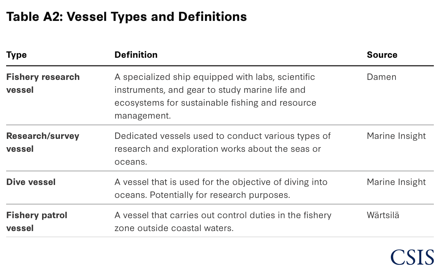
The Futures Lab identified vessels of interest using the International Research Vessel Schedules & Information dataset from the Ocean Information Center at the University of Delaware. This dataset was supplemented with public reporting of survey vessels studying the seafloor. Vessels thus identified were then cross-referenced against marinetraffic.com information to acquire vessel types and maritime mobile service identity (MMSI) numbers. This narrowed the of-interest dataset to 223 vessels identified as one of the following: fishery research vessel, research/survey vessel, dive vessel, special vessel, and fishery patrol vessel (see Table 2A for definitions).2 Next, the research team queried the AIS data from General Atomics’ Optix platform for the 223 vessels of interest over the period spanning January 1, 2020, to December 9, 2025.3 Lastly, to enhance the AIS data, the team collected spatial layer information including EEZs and high seas from marineregions.org, gas pipelines from the Global Energy Monitor, prospective critical mineral regions as labeled by the U.S. Geological Survey (USGS), and Optix’s subsea fiber-optic cable map for processing geospatial joins.4
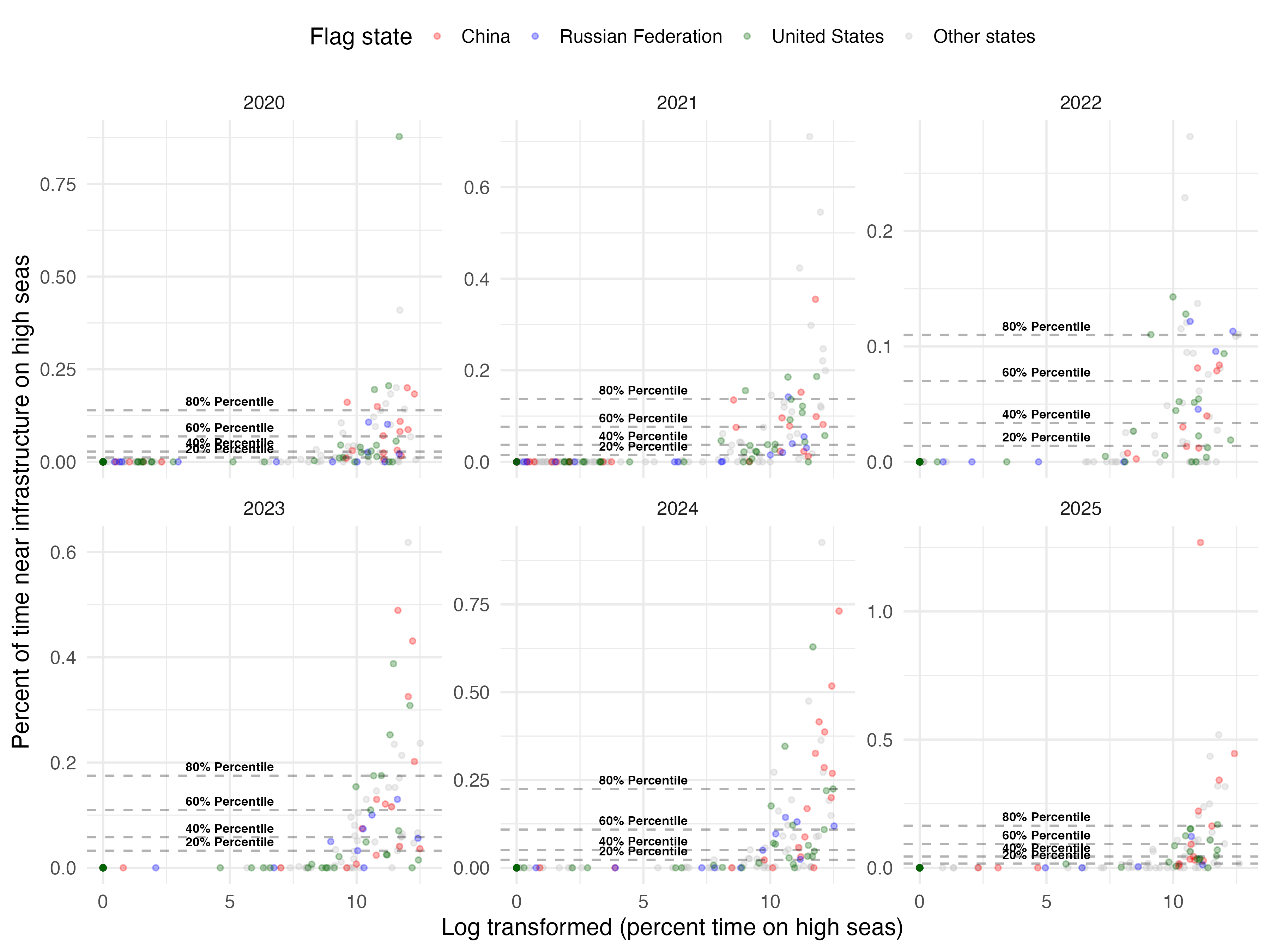
PRC research vessels spend a statistically significant share of their observed time near subsea infrastructure on the high seas relative to most national research fleets. Scientific activity on the high seas is subject to limited international oversight, creating opportunities for states to collect valuable underwater data under the cover of dual-use research missions.5 The Futures Lab’s team analyzed the share of time vessels spent near critical infrastructure and found that most of the 47 (non-PRC) nations’ research vessels did not spend much time near subsea cables on the high seas.6 Figure 2 places the activity of the three major powers in a broader context by comparing the annual share of time that PRC, Russian, and U.S. research vessels spent near subsea cables on the high seas between January 1, 2020, and December 9, 2025.
PRC activity was especially pronounced in 2024, when seven of its research vessels ranked above the 80th percentile for time spent near subsea infrastructure on the high seas.
For most vessels in the dataset, this activity accounted for less than 1 percent of observed time each year. The three major powers, unsurprisingly, consistently ranked among the most active fleets, showcasing that competition for access to underwater data is an important component of their deep-sea research operations. U.S.-flagged vessels ranked above the 80th percentile in all five annual comparisons, PRC-flagged vessels did so in four, and Russian-flagged vessels in two. PRC activity was especially pronounced in 2024, when seven of its research vessels ranked above the 80th percentile for time spent near subsea infrastructure on the high seas. This persistent and disproportionate activity reveals that the PRC is leveraging its research fleet for underwater data collection that may aid in the systemic analysis of terrain for sabotage or submarine operations.
Figure 2: Research Vessel Time Near Infrastructure by Country
Source: Authors’ analysis of AIS data from General Atomics Intelligence Optix.
Additional regression analysis supports the conclusion illustrated in Figure 2: PRC-flagged research vessels spend disproportionately more time near subsea infrastructure on the high seas. More specifically, when compared with research vessels from the other countries represented in the dataset, PRC vessels are positively and statistically significantly associated with a greater share of observed time in these locations. As reported in Table A3 in the appendix, U.S.-flagged vessels also exhibit a positive association, although the relationship is weaker and only marginally significant. Russian-flagged vessels exhibit a negative association, though it is not statistically significant. Taken together, the year-over-year distributions and regression results identify the PRC fleet as exhibiting the clearest and most consistent pattern of persistent ambiguous activity near subsea infrastructure on the high seas. Although these results do not independently establish the intent of specific missions, they do strengthen the inference that PRC research vessels perform dual-use data collection that may contribute to systematic seabed analysis relevant to submarine operations or infrastructure sabotage.
While the research findings establish a broad pattern, examining individual vessel behavior reveals the strategic significance of dual-use research activity. The cases below illustrate how statistically unusual activity appears in an operational context. The Futures Lab chose the vessels Xiang Yang Hong 06 and Ke Xue as exemplars because they ranked among the most active PRC research vessels near subsea infrastructure on the high seas, displayed repeated survey-like movement patterns, and operated near strategically significant cable systems that were outside areas with obvious mineral prospectivity. These two vessels thus showcase persistent, ambiguous activity by state-linked research vessels in locations where undersea data would be valuable for future military planning, surveillance, or sabotage.
Of the research vessels identified in the 80th percentiles, the Xiang Yang Hong 06 stood out as an outlier, falling within the 90th percentile and consequently labeled as a vessel with persistent ambiguous activity. This vessel was previously reported to carry sonar and deep-sea sampling equipment and had been highlighted for its journey mapping the sea floor in a grid or lawnmower pattern near strategic areas. What is less known to the general public is the strategic importance of the subsea cable connections it loitered near and mapped.
Figure 3: Xiang Yang Hong 06 Activity, February–May 2024
Source: AIS and fiber-optic cable data from General Atomics Intelligence Optix; EEZ locations from marineregions.org.
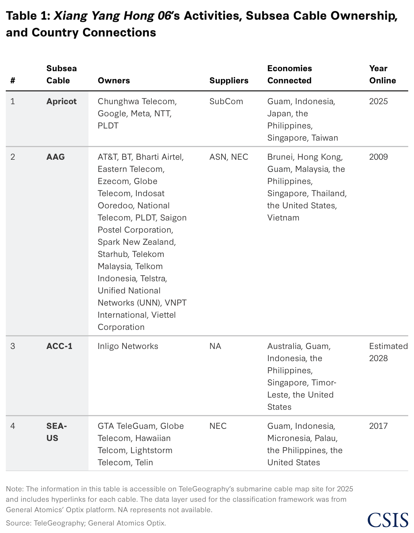
As shown in Figure 3, between February and May of 2024, the Xiang Yang Hong 06 made three trips to the high seas off the coast of Guam, focusing on an area approximately 210 nautical miles from the coast of Guam in which it mapped critical infrastructure. Its survey activities covered two subsea cables: the Apricot and the ASIA-America (AAG) Cable System, the latter with connectivity to the United States. The Apricot connects six economies: Guam, Indonesia, Japan, the Philippines, Singapore, and the main island of Taiwan. The second subsea fiber-optic cable, the AAG, connects nine economies: Brunei, Guam, Hong Kong, Malaysia, the Philippines, Singapore, Thailand, the United States, and Vietnam. The Xiang Yang Hong 06’s mapping activities all occurred outside the United States’ EEZ around Guam and on the high seas, likely to avoid requesting permission to map the seafloor. Both cables would be prime military targets in a military crisis between the United States and the PRC.
Importantly, these survey activities occurred outside the Prime Crust Zone (PCZ), a region in the central-western Pacific where cobalt-rich ferromanganese crusts—containing critical mineral deposits—are most likely to occur. In addition, the survey activities occurred outside the U.S. Geological Survey’s prospective occurrence regions layer (hereafter, exploration regions). Both the PCZ and the exploration regions comprise areas where geological and oceanographic conditions are favorable for critical mineral formation, such as seamounts, ridges, and abyssal plains characterized by low sedimentation rates, and therefore represent potential critical mineral sources. By contrast, the Xiang Yang Hong 06’s survey tracks are concentrated east of Guam—outside of likely mineral-rich regions—and in areas with subsea infrastructure, suggesting that the vessel’s operations are likely aligned with mapping and characterizing strategically significant undersea systems rather than with more scientific purposes.
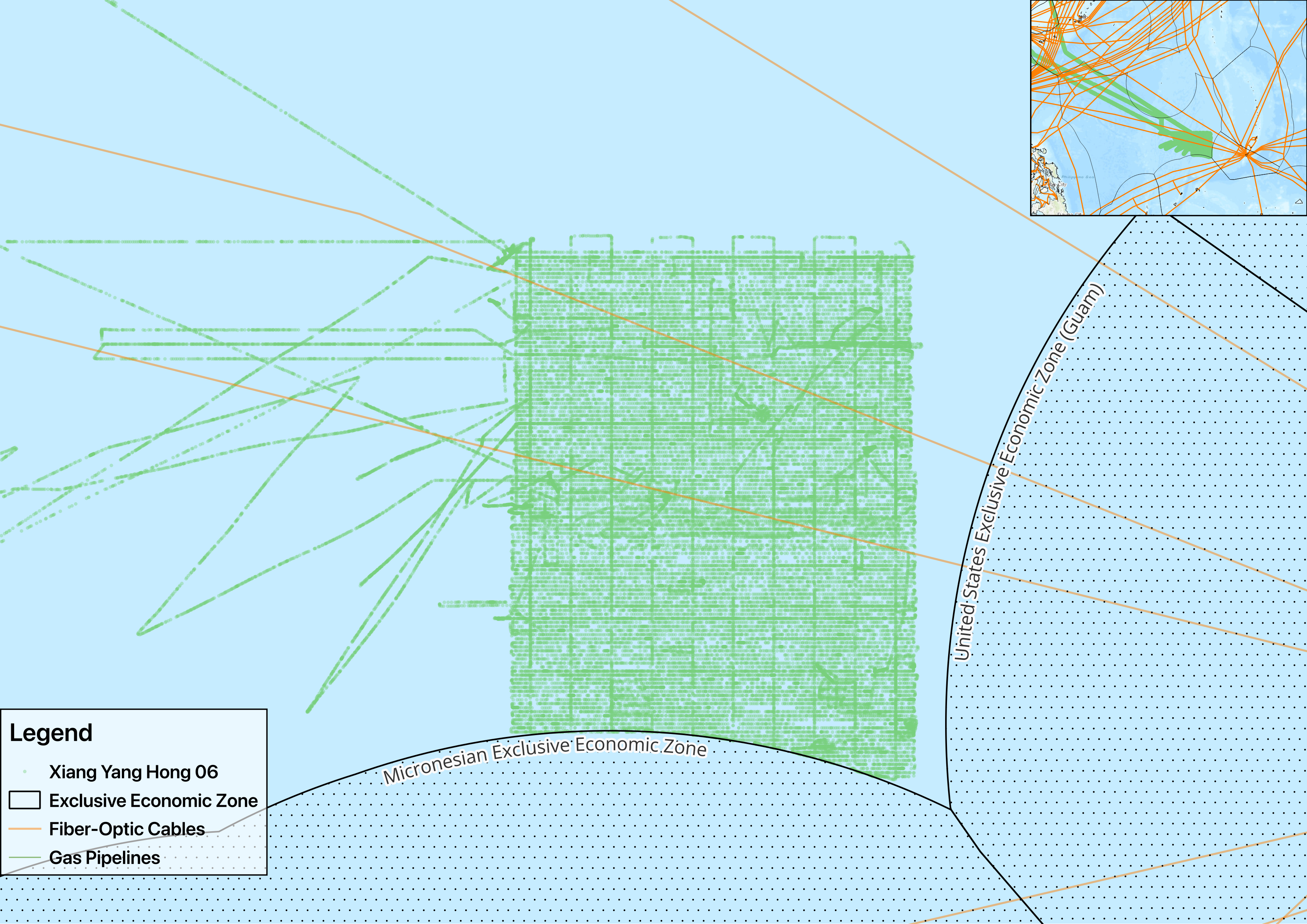
Figure 4 represents the Xiang Yang Hong 06’s July 2024 journey to the east of Guam, outside the latter’s EEZ and on the high seas, covering an area that includes three cables, one under development and two operational. The survey’s July activities encompassed the Asia Connect 1 (ACC-1), the AAG Cable System, and the Southeast Asia-United States (SEA-US) Cable System. The ACC-1 is estimated to be completed by 2028 and connects six countries and territories: Australia, Guam, Indonesia, Singapore, Timor-Leste, and the continental United States. The final cable mapped, the SEA-US, connects six countries and territories: Guam, Indonesia, Micronesia, Palau, the Philippines, and the United States.
Figure 4: Xiang Yang Hong 06’s Initial Pass, July 1–31, 2024
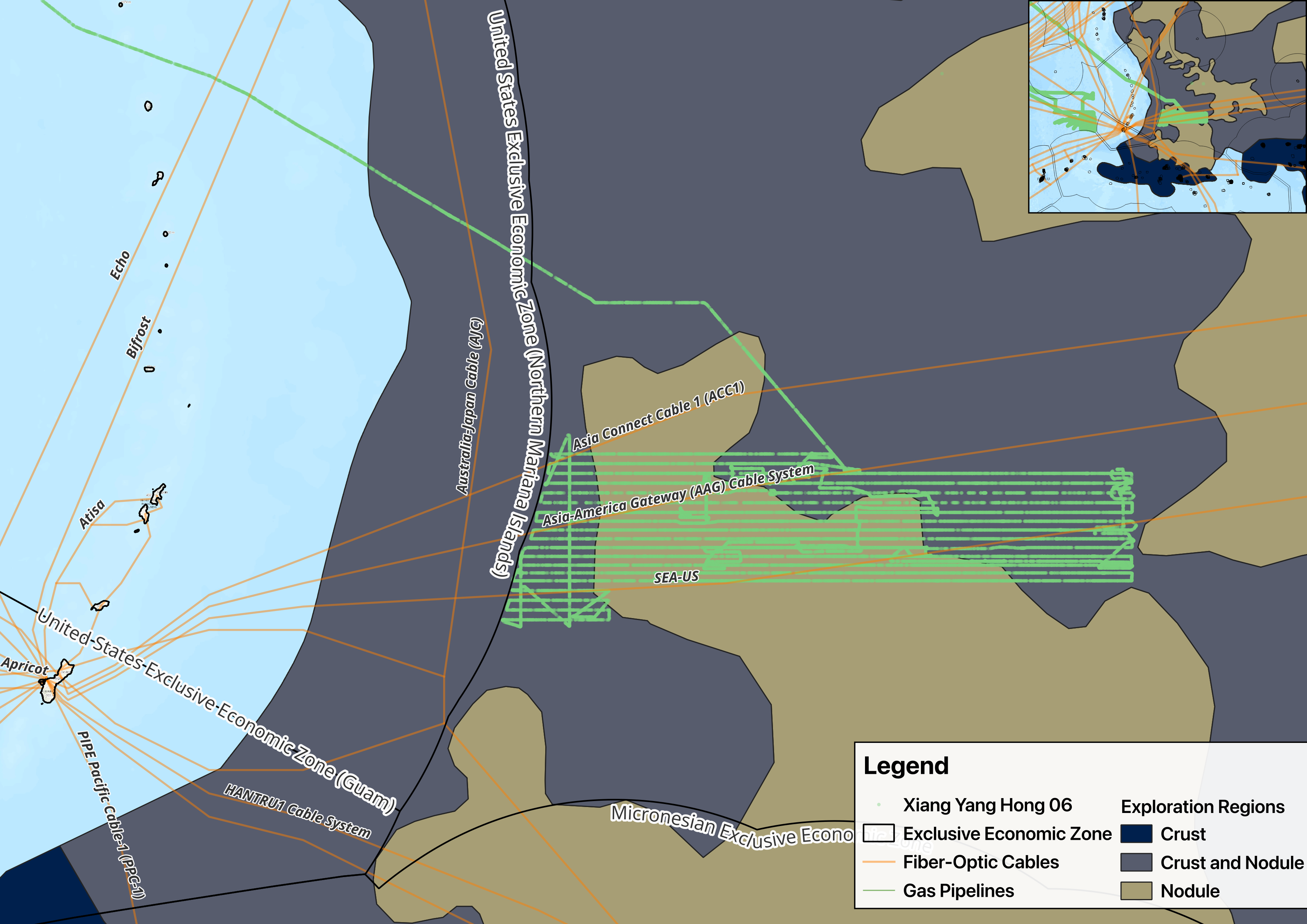
Sources: AIS and fiber-optic cable data from General Atomics Intelligence Optix; EEZ locations from marineregions.org; and exploration regions from USGS.
The PRC vessel’s expanded survey from August through October 2024 illustrates how dual-use research activity can combine strategic data collection with a plausible civilian explanation. As shown in Figure 5, the vessel continued exploring the region with a similar pattern, but expanding both its scope and density, likely switching from an ISR mission focused on subsea fiber cables to a civilian mission mapping the sea floor for potential mineral deposits within exploration regions, such as nodules or crust and nodule deposits. Table 1 supports this conclusion, revealing the strategic significance of this activity: None of the intersected cable systems is owned or operated by a PRC-based entity, indicating an avoidance of PRC-based systems. This increases the likelihood that the vessel was intentionally surveying the routes of foreign-built infrastructure and, furthermore, demonstrates how the PRC uses its research vessels under a scientific rationale that complicates attribution and preserves plausible deniability.
Figure 5: Xiang Yang Hong 06’s Expanded Survey Mission, August 14–October 27, 2024
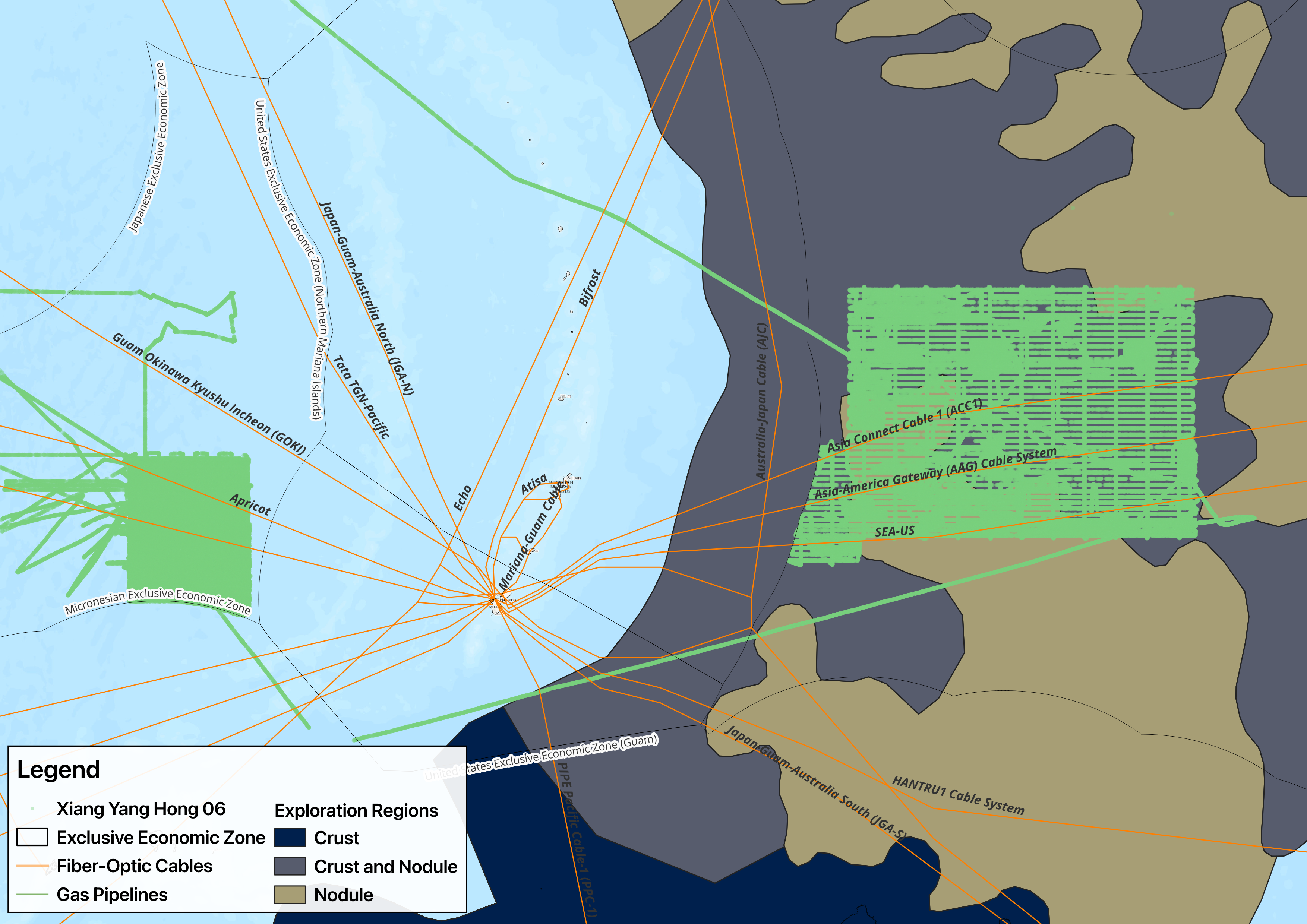
Sources: AIS and fiber-optic cable data from General Atomics Intelligence Optix; EEZ locations from marineregions.org; and exploration regions from USGS.
The case of the Xiang Yang Hong 06 reveals the dual-use survey missions near subsea cable systems on the high seas, including cables that link Guam, the continental United States, and U.S. partners across the Indo-Pacific. The vessel’s movements occurred on the high seas, beyond the clear consent requirements that would apply inside a coastal state’s EEZ, and, at least initially, outside areas with obvious mineral prospectivity. Considering Guam’s strategic importance to the Pacific theater as both a logistics and a forward-deployment hub on the second island chain, losing undersea cable connectivity for Guam would cause significant stress to U.S. Pacific Command’s (PACOM) network, particularly during a conflict, as the volume of communications in the area would expand to coordinate logistics support, troop movement, and flight deconfliction. Such military coordination would be forced to share the limited space-based communications bandwidth with equally essential early-warning ISR, multidomain awareness, and fire coordination. Even during peacetime, a Chinese state-owned scientific research ship such as the Xiang Yang Hong 06 can serve as an additional ISR asset to provide positive identification of U.S. military activities in the vicinity of Guam. The case, therefore, both offers support for this analysis’s broader conclusion that PRC-linked research vessels are more active near subsea infrastructure than most other national fleets and also reveals that this activity occurs in locations where the undersea data thus collected could support future military planning, surveillance, or coercive options.
The Ke Xue case demonstrates how persistent ambiguous activity can extend across multiple strategically important cable corridors while remaining under the facade of scientific research. The classification framework employed here identified the Chinese-flagged vessel as exhibiting persistent ambiguous activity in 2024. Launched in 2011, the Ke Xue carries deep-sea exploration and sampling gear and has been referenced as a “mobile ocean lab.” As shown in Figure 6, Ke Xue began a survey-like mission in March 2024 approximately 290 nautical miles west of Japan’s Okinotori Island, a geographical feature comprising approximately 108 square feet at high tide and located halfway between Taiwan and Guam, and whose legal status has been a matter of dispute for over two decades. Moreover, the Ke Xue’s activity occurred on the high seas, outside both the PCZ and the mineral exploration regions identified by the U.S. Geological Survey. The vessel’s survey location and movement pattern therefore raise questions about whether mineral research alone adequately explains its repeated, prolonged operations near non-PRC-based subsea infrastructure.
Figure 6: Ke Xue's Survey Missions, March–June 2024
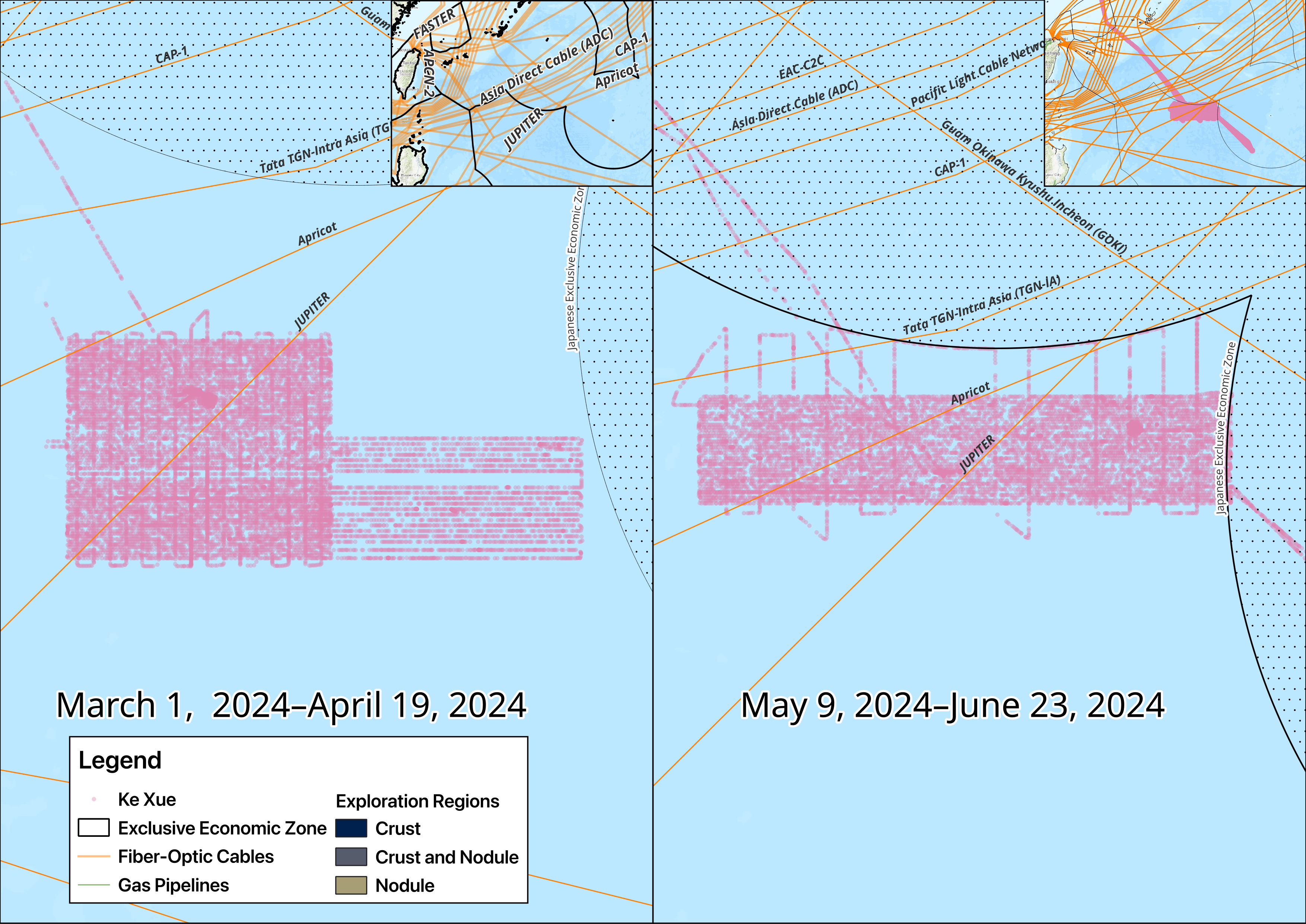
Sources: AIS and fiber-optic cable data from General Atomics Intelligence Optix; EEZ locations from marineregions.org; and exploration regions from USGS.
The Ke Xue made two passes through the area between March and April of 2024, before returning to port and then resuming operations in the same area in May. Across these missions, the vessel’s survey tracks repeatedly crossed or approached three major cable systems—the Tata TGN-Intra Asia (TGN-IA), Apricot, and JUPITER—while avoiding known mineral-exploration regions. TGN-IA connects Hong Kong, the Philippines, and Vietnam and links to Tata TGN-Pacific, which extends connectivity to Guam, Japan, and the continental United States. Apricot links Guam, Indonesia, Japan, the Philippines, Singapore, and Taiwan, while JUPITER similarly connects Japan and the Philippines with the United States. These systems form part of the communications architecture linking the United States with its allies, partners, and military facilities in the Western Pacific.
With these journeys, the Ke Xue challenged Japan’s claimed EEZ near Okinotori Island and displayed survey-like movements approximately 150 nautical miles from the island. Based on the CCP’s widely known hybrid warfare strategy of advancing without attacking, it is likely the vessel intentionally conducted marine scientific research in the area without Japanese consent, specifically to normalize PRC claims to the island—or, at least, to normalize PRC claims that the feature is not legally an island or continental shelf and therefore does not create a 200-nautical-mile EEZ for Japan. These missions are consistent with previously reported disputes involving PRC research vessels near Okinotori Island in 2019 and 2025. The Ke Xue’s activities around Okinotori thus further illustrate how the PRC leverages its academic fleet for dual-use missions and amplify the ambiguity surrounding PRC-linked research vessel activity.
The Ke Xue’s subsequent activities add credence to these conclusions. Beginning in mid-July 2024, the vessel traveled north through the Sea of Japan and the Tsugaru Strait before entering the Bering Sea. As Figure 7 illustrates, the Ke Xue continued its trend of avoiding known mineral-exploration regions while following diagonal, survey-like tracks near at least 10 subsea cable systems connecting East Asia, Japan, and North America. This northern transit highlights the significance of the vessel’s activity—the Ke Xue focused not on a single cable or an isolated scientific destination, but rather on geographically dispersed infrastructure corridors, repeating its earlier operational pattern.
Figure 7: The Ke Xue's Northern Mission, July 15–August 28, 2024
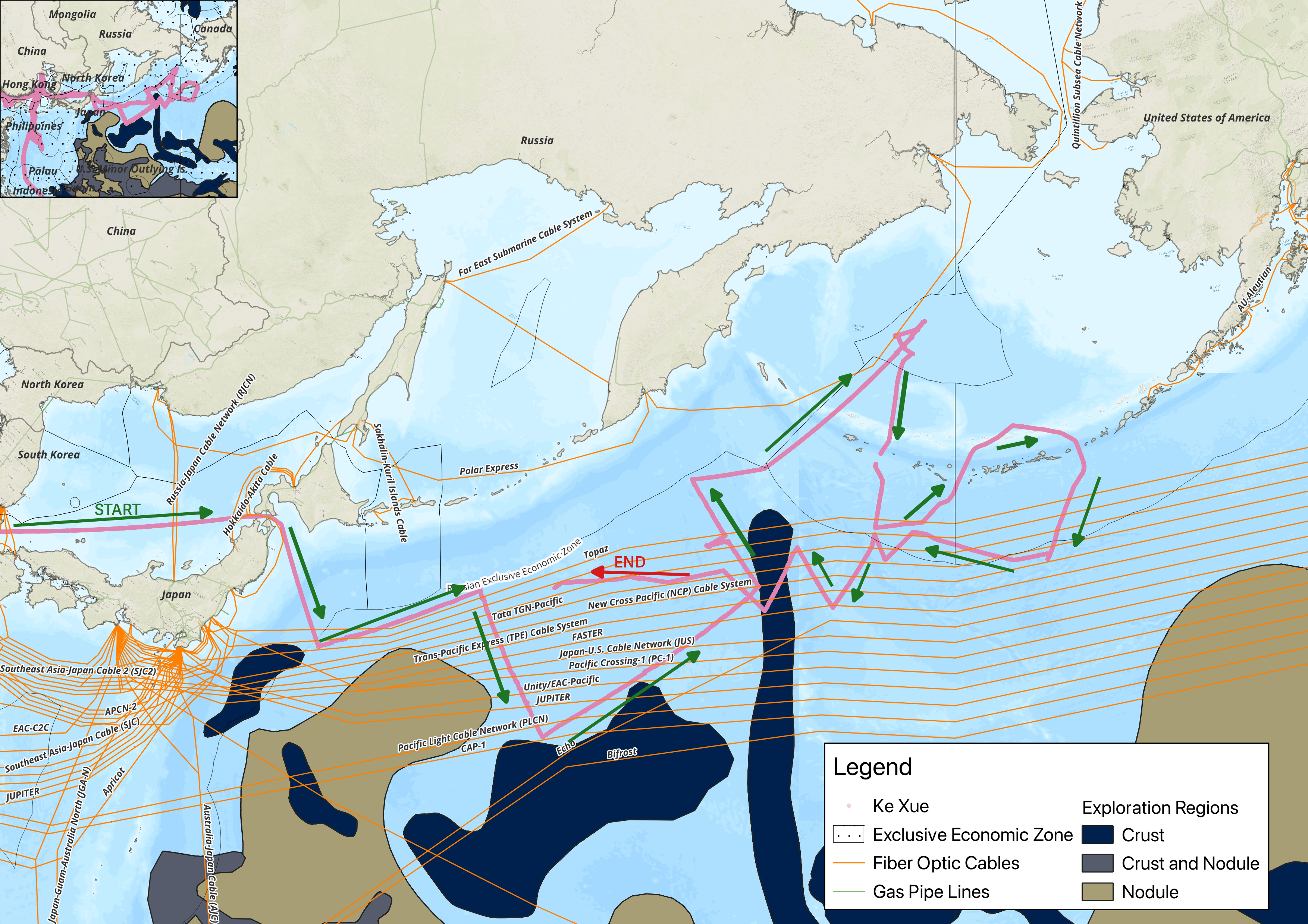
Sources: AIS and fiber-optic cable data from General Atomics Intelligence Optix; EEZ locations from marineregions.org; and exploration regions from USGS.
The eight subsea cables surveyed in the Ke Xue’s northern journey include Topaz, JUPITER (previously identified), the New Cross Pacific (NCP) Cable System, FASTER, Pacific Crossing (PC-1), Tata TGN-Pacific, the Trans-Pacific Express (TPE) Cable System, the Unity/EAC-Pacific, and the Pacific Light Cable Network (PLCN). These eight cables offer different connection points to Asia: The Topaz connects two countries, Canada and Japan; the NCP connects five countries and autonomous regions, including Japan, mainland China, South Korea, Taiwan, and the United States; FASTER and PLCN connect Japan and Taiwan to the United States; the PC-1 and the Unity/EAC Pacific systems connect Japan and the United States; the Tata TGN-Pacific links Japan and Guam to the United States; and finally, the TPE connects four countries or autonomous regions—Japan, mainland China, South Korea, and Taiwan—to the United States. As summarized in Table 2, the systems are owned by various combinations of technology and telecommunications companies, including U.S. companies such as Google, Microsoft, Meta, Amazon Web Services, and AT&T, and several major Asian carriers.
As with the Xiang Yang Hong 06, the PRC-linked Ke Xue is surveying infrastructure mostly owned by non-PRC-based entities and located outside regions with higher likelihoods of critical mineral exploration or greater scientific value. This behavior exposes the Ke Xue’s use for dual-use missions, including gathering data near infrastructure and collecting scientific information.
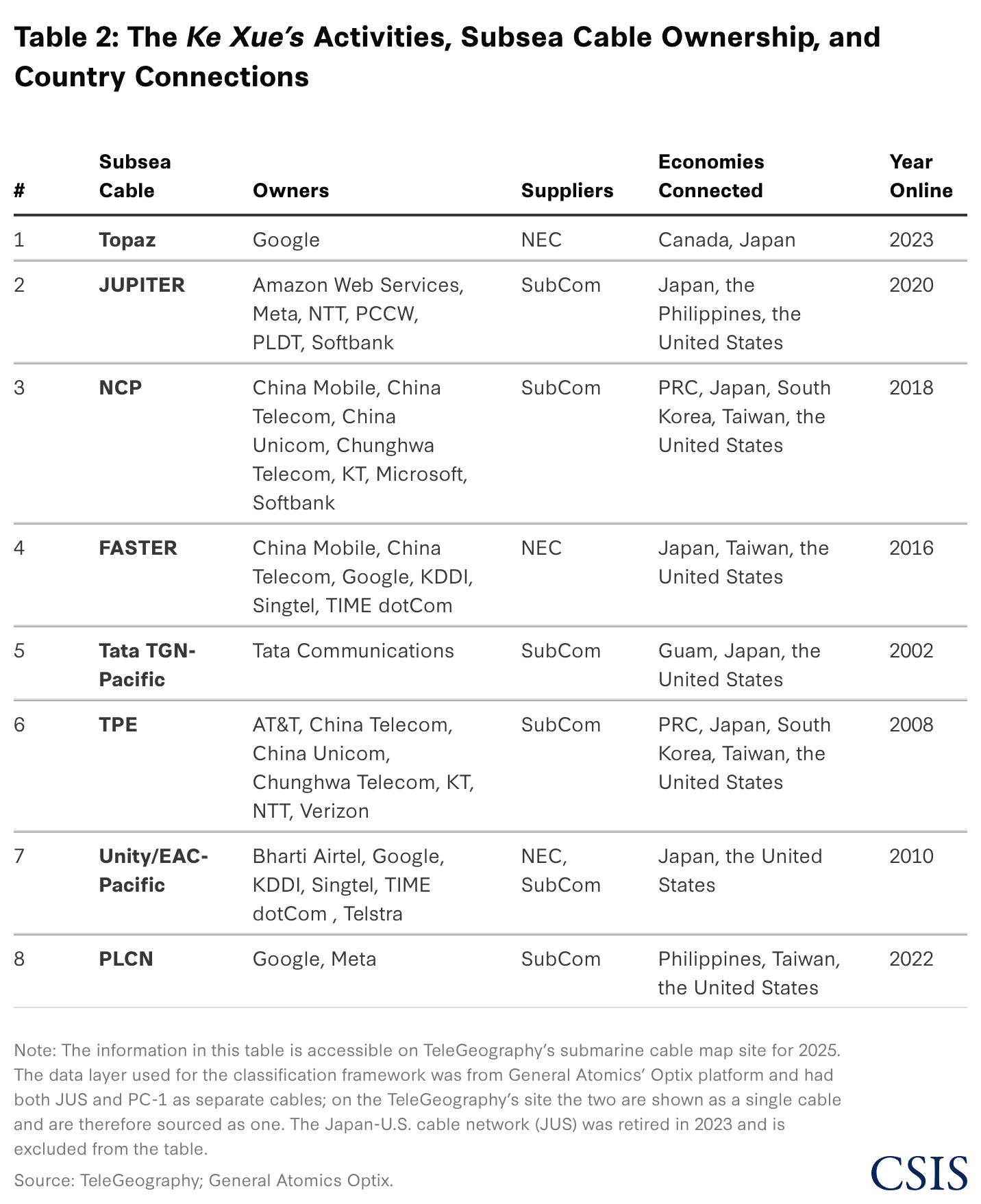
The Ke Xue’s activity in the Bering Sea focused on infrastructure and a U.S. military base. After leaving Russian and U.S. EEZs, the vessel began survey-like movements on the high seas near Polar Express, a Russian government–owned cable. This was an unexpected finding and likely reveals PRC interest in carrying out ISR on Russia’s subsea telecommunications infrastructure. On its return route through the Near Islands, the Ke Xue temporarily stopped transmitting AIS at about 40 nautical miles east of Shemya Island, which is located at the western edge of the Aleutian Islands, about 100 miles from Russian waters, and is home to Eareckson Air Station. A central part of the third island chain, Eareckson Air Station serves as a staging ground for the United States to deploy assets to the Asia Pacific. In the event of a conflict with the PRC, the Aleutian Islands would be operationally critical to protect sea lines of communication in the North Pacific and traffic to the Arctic. The Ke Xue’s northern journey built on the routes of joint PRC-Russian patrols near the Aleutians that challenged U.S. readiness in the third island chain. After masking its AIS location near Eareckson, the Ke Xue reappeared approximately three hours later—nearly 30 nautical miles from its last reported position—before heading south, crossing the Topaz, PC-1, and Tata TGN-Pacific cables. As such, the Ke Xue journey to the Bering Sea likely mapped both Russian critical infrastructure and underwater terrain near U.S. staging sites.
This was an unexpected finding and likely reveals PRC interest in carrying out ISR on Russia’s subsea telecommunications infrastructure.
The Ke Xue’s activities highlight the national security risks posed by dual-use vessels. The undersea cable mapping draws attention to the potential for significant degradation of communication capacity between the continental United States and the U.S. military commands and allies in the first and second island chains. The U.S. military bases in Japan and South Korea are responsible for sortie generation and material readiness in a potential contingency scenario—for example, over Taiwan or the South China Sea and involving a rapid, large-scale response. Degrading subsea cables could disrupt coordination at the operational and strategic levels between forward-deployed forces and commands based in the continental United States.
In addition, the Ke Xue demonstrates how PRC research vessel activity near subsea infrastructure is not confined to a single geography or cable network, revealing the larger PRC strategy of undersea information dominance. In 2024, the vessel conducted repeated survey-like movements near Western Pacific cable systems linking Guam, Japan, the Philippines, Taiwan, and the United States before transiting north toward the Bering Sea and operating near cables connecting East Asia, Russia, Alaska, and North America. These movements occurred largely on the high seas and, in several instances, outside areas with obvious mineral prospectivity, making the subsea infrastructure a more plausible explanation for the vessel’s operational pattern. The AIS signal gap near Shemya Island should not be overstated, but in this context, it strengthens the case for monitoring PRC research vessels as persistent ambiguous actors near critical undersea systems. Ke Xue thus connects the paper’s statistical findings to the systematic blurring of academic research ships’ scientific missions with the larger PRC goal of undersea information dominance. The vessel’s tracks clearly show journeys outside known scientific collection and exploration areas, and, more significantly when considering potential wider implications, intentional proximity to infrastructure that would matter in a future crisis or conflict.
The difficulty of distinguishing legitimate scientific research activity from dual-use missions exposes an international policy and legal gap. Existing monitoring and authorization mechanisms focus heavily on territorial jurisdiction or individual incidents, not on long-term or widespread activity, particularly on the legally ambiguous high seas. This provides an opportunity for vessels such as the Ke Xue to operate across jurisdictions and conduct gray zone operations on the high seas largely unnoticed. In isolation, a specific survey pattern, cable crossing, port visit, or AIS interruption may have an innocuous explanation. However, when such indicators recur across multiple voyages and at strategically important locations, they can reveal a pattern of persistent ambiguous activity that incident-based monitoring fails to capture. Countering dual-use gray zone activity therefore cannot depend on proving the intent behind each mission. It must instead identify cumulative, long-term behavioral patterns, coordinate information and operational responses across different national jurisdictions, and strengthen infrastructure resilience against the disruption these missions could enable.
Damage to undersea cables could disrupt the global economy, communications, and allied military coordination. The United States and its allies and partners therefore need a multilateral approach that combines information sharing, law enforcement presence, and increased repair capacity.
This approach should focus on deterrence by detection and exposure and include three goals for the United States, its allies, and partners. First, they should strengthen maritime domain awareness (MDA) near critical infrastructure, particularly on the high seas, and publish evidence of suspicious PRC and Russian activity. This is needed to inform the public and researchers on new surveys and patterns that provide insight into where the PRC or Russia could cause damage to communications. Identifying the locations of suspicious activities can help prioritize unmanned surveillance and future repair efforts. Second, U.S. allies and partners should maintain a persistent maritime law enforcement presence in sensitive areas of the high seas. Third, they should invest in regional repair hubs and multinational repair fleets. Participating governments should also pool historical vessel data patterns and publish recurring assessments. These measures would help allies and partners identify patterns, coordinate responses, and deter gray zone activities.
For example, the United States’ single dedicated cable repair ship is more than 40 years old; its work is supplemented by two chartered commercial vessels.
The CCP treats its research fleet as a dual-use instrument capable of supporting both scientific missions and military preparations. Its research vessels collect oceanographic information that could support undersea intelligence gathering, submarine operations, or future attacks on critical infrastructure. This report’s analysis of AIS data shows that PRC-linked research vessels spent a disproportionately large share of their observed time near critical infrastructure compared with research vessels from 47 other countries. While these findings do not establish the intent of individual missions, they do identify a persistent pattern of activity in locations where undersea data could have significant military value.
The United States and its allies and partners should act in three areas:
Together, these measures would improve deterrence by detection and exposure, while also increasing MDA and resilience against future attacks. The intent of these recommendations is not to prevent legitimate scientific research on the high seas, but rather to identify persistent patterns of intelligence collection and ensure communications will survive disruptions.
Please consult the PDF for references.
Jose M. Macias III is an associate data fellow and data scientist in the Futures Lab within the Defense and Security Department at the Center for Strategic and International Studies (CSIS) in Washington, D.C. He applies data science, computational methods, and geospatial analysis to national security and defense challenges. Tao-Hung Chang, Taiwan’s visiting military fellow at CSIS, brings extensive naval experience and subject-matter expertise in undersea warfare and international security cooperation to the research. Nico Vacca is a research assistant with the Futures Lab. Benjamin Jensen is the director of the Futures Lab and a senior fellow for the Defense and Security Department at CSIS.
This report is made possible by generous support from General Atomics.
The authors wish to thank Kathleen Lord Fallon, the U.S. Coast Guard military fellow with the CSIS Defense and Security Department, for her review, feedback, and suggestions, which the team incorporated into the report.
This white paper is a policy adaptation of a conference paper submitted to the 6th Maritime Security Conference in Istanbul, Turkey. A related publication, titled “Surveying the Battlespace: How Russian and Chinese ‘Research’ Vessels Map Critical Undersea Infrastructure,” is forthcoming from the Maritime Security Center of Excellence.
Operationalizing the team’s key argument, the research hypothesis is as follows:

Developing a framework to categorize activities aided in identifying expected activity and determining a baseline against which to measure potential gray zone activities. Table A1 represents the classification framework operationalized in this analysis. Thresholds are informed by public reporting of dual-use vessels and defined using distributional cutoffs, allowing vessels to be evaluated relative to expected research activity across the full dataset.
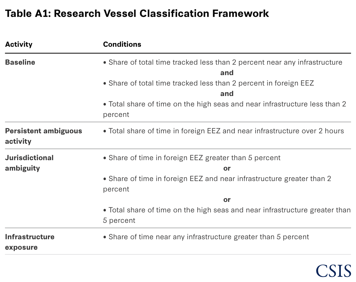
To operationalize the study’s hypothesis, this paper leverages commercial data provided through a partnership between the CSIS Futures Lab and General Atomics Intelligence, using data from its Optix platform. The AIS data was preprocessed using the R programming language with the simple features (sf) and arrow packages to convert the data into the Parquet format for each year of study, reducing storage requirements. The AIS data was imported into ArcGIS, along with spatial layers for EEZ, high seas, gas pipes, and subsea fiber-optic cables, and then reprojected to the Spilhaus Projection (ESRI:54099). Within ArcGIS, the team applied buffer analysis to increase the size of the gas pipes and fiber-optic cables by one kilometer to capture unmanned underwater vehicles and research vessels near the selected sites, helping to offset the imprecision of the cable locations in the layer naturally occurring over time. This was complemented by spatial joins across the layers to extract attribute features and append them to the AIS data, thereby producing binary columns for when a vessel was in an EEZ, on the high seas, in an exploration region, near gas pipes, or around subsea fiber-optic cables. Lastly, the team operationalized the classification framework in Table A1 as an algorithm in R. The final dataset was aggregated by MMSI and year and then analyzed using a regression model, as discussed in the results section and shown below in Table A3. To provide robustness checks, the team incorporated additional regressions that included a fixed year effect, revealing 2024 as a year with statistically significant activity (see Table A4).
The curation of the dataset was followed by gathering data from marinetraffic.com.
To evaluate the hypothesis, the authors designed the following regression formula:

The dependent variable (Y) is defined as the share of time on the high seas near subsea infrastructure. The time is calculated and estimated based on the time stamp for each observation of a unique vessel according to the vessel’s MMSI.
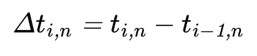


As such, Y is defined as representing the share of time by a vessel spent on the high seas and within subsea infrastructure (gas pipes or fiber-optic cables) relative to the estimated time for a given vessel present in the data.
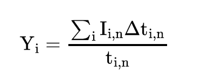
The cumulative amount of time is aggregated up to a year and then summarized as the mean—i.e., the estimated share of time the vessel n is within or crossing subsea infrastructure on the high seas.7
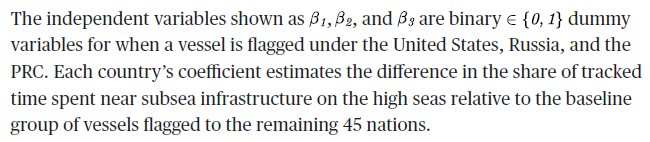
Lastly, the error term is defined by epsilon and contains unobservable determinants of the dependent variable.
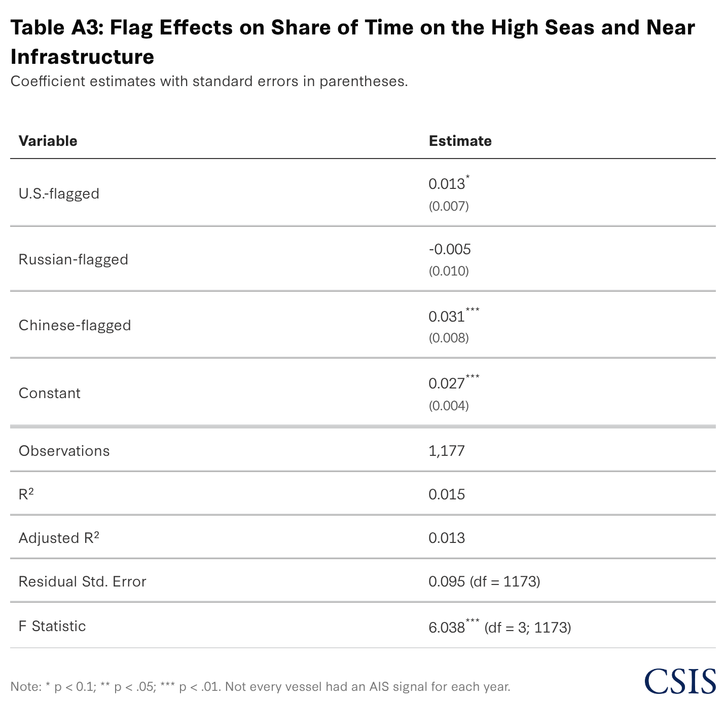
The research team ran additional robustness checks to correct for heteroskedasticity using robust standard errors, fixed effects (FE), random effects (RE), and clustered effects. The results showed that Chinese-flagged vessels continued to be statistically significant at the 0.05 level, while the significance of U.S.-flagged vessels drops and returns depending on the additional model (see Table A4). Taken together, these models lend partial support to the initial research hypothesis that PRC- and Russian-linked research vessels are being used for dual-use activities at higher rates than U.S. research vessels, with the effect being more pronounced for PRC vessels than for Russian-linked vessels.
One limitation that should be noted is that the adjusted R2 indicates that the Futures Lab’s model only explains an estimated 1.3 percent of variation in the data, and the model could benefit from additional relevant covariates and a larger sample size of distinct research vessels.
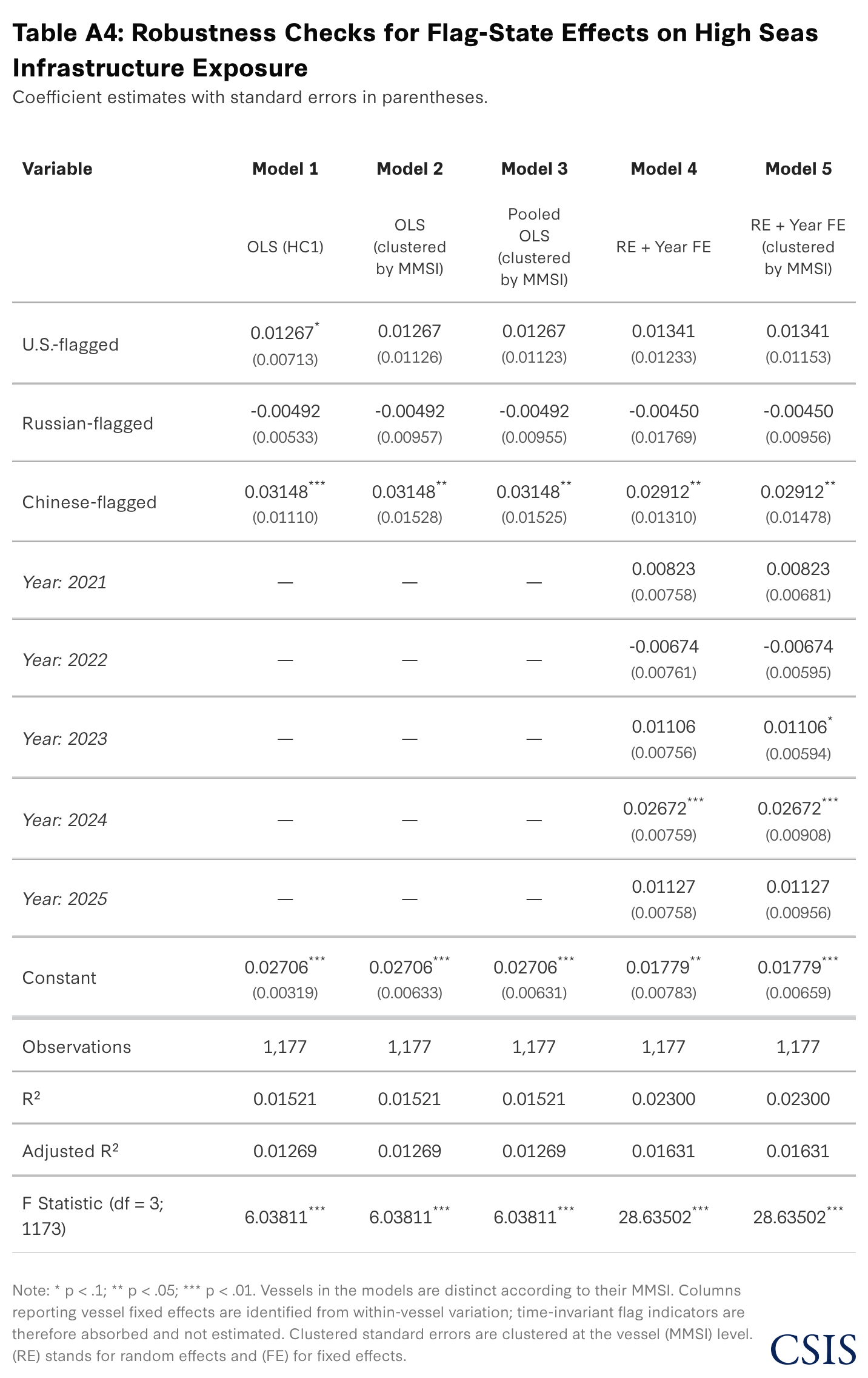
Table A4 reports robustness checks of the main OLS model described in the results section. Across all variants, vessels flagged as Chinese remain positive and statistically distinguishable from zero, while the U.S. and Russian-flagged vessels are not statistically significant. In the baseline OLS model (Table A3), the China flag variable coefficient is an estimated 0.0315 (p < 0.001), and it remains significant both under heteroskedasticity-robust (Table A4, Model 1) and vessel-clustered standard errors (Table A4, Model 2) (p ≈ 0.040) and within the random effects panel model with vessel-clustered errors (p ≈ 0.049) (Table A4, Model 5). This consistency suggests that the direction of the China association is relatively stable, though its precision weakens under more conservative error structures. At the same time, all models have low explanatory power (R2 and adjusted R2 roughly 0.02 or lower), indicating that flag-state indicators explain only a small share of variation in vessel time near high seas infrastructure. These checks therefore continue to provide support but are limited. The models would benefit from relevant additional covariates and instrumental variables as appropriate for the study of gray zone activity.

Brief by Jose M. Macias III and Benjamin Jensen — October 8, 2025

Commentary by Joel Coito — December 12, 2025

Report by Erin L. Murphy — November 21, 2025