Satellite imagery indicates that sometime between July 2014 and August 2015 a new air defense missile base was established west of the Rogachevo air base, accompanied be a regiment-sized unit equipped with the S-300P (NATO reporting name: SA-10 Grumble) surface-to-air missiles (SAM).3 Upgrades to air defense capabilities on Novaya Zemlya occurred during 2018 and 2019 and included the deployment of additional radar, electronic warfare (EW), signals intelligence forces, and related equipment in addition to the deployment of the S-400 (an upgrade from the S-300P), with the latter occurring during the July-August 2019 time frame.
On September 16, the Russian Northern Fleet Press Service reported that the redeployment of forces and conversion to the S-400 systems were complete.4 A few days later, on September 20, the Press Service published a report on the ceremony celebrating the unit’s achievement of operational status.5 Why is this important?
ANALYSIS
THE IMPORTANCE OF S-400S IN THE ARCTIC
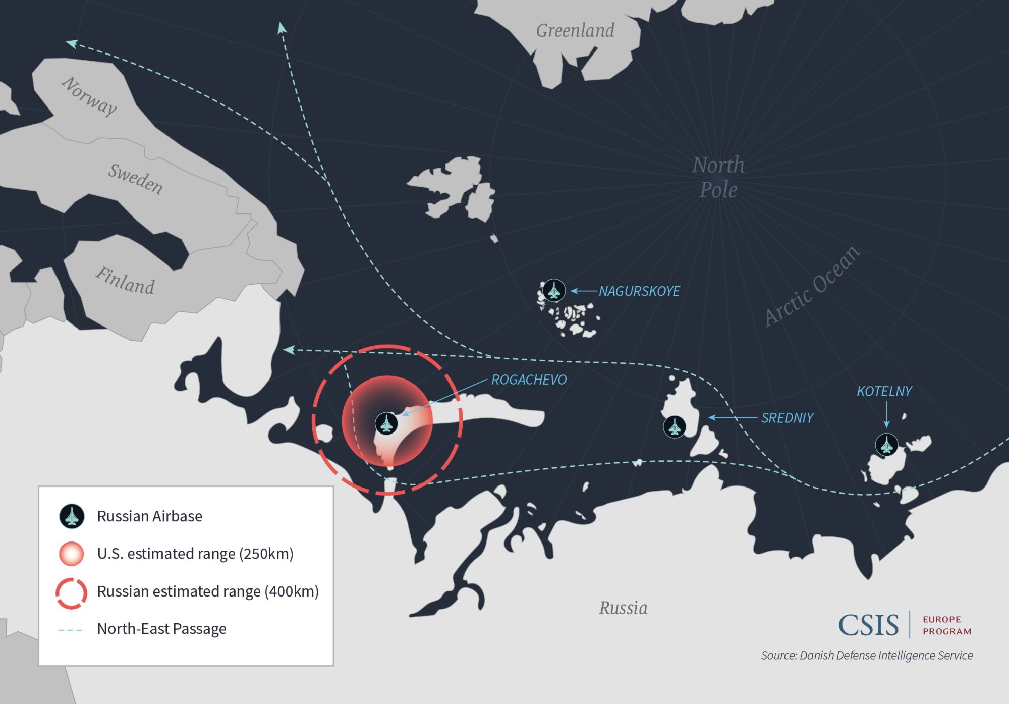
Russia’s military posture in its Western Arctic reflects the Soviet legacy of bastion defense comprised of “concentric circles” designed to protect strategic territory.6 The S-400s provide more advanced radar and EW systems capabilities, which expand the range of Novaya Zemlya’s air defenses. The airspace monitored and controlled from Rogachevo air base has now increased to 600 kilometers for detection and 400 kilometers for engagement, according to Russian assessments, although Western analysts estimate the range to be between 200-250 km based on the system’s current configuration.7 The S-400 reportedly reduces deployment time from stowed position to launch to five minutes and compliments previously implemented enhanced defensive measures, including the establishment of two Arctic motorized brigades, an Arctic naval group, and a command and control center at the refurbished Severomorsk-1 air base.8
Russia’s priority in the Arctic is to defend its northwest coast and the surrounding maritime domain around the Northern Fleet, Russia’s most capable force, which includes ballistic missile submarines and surface combatants that are deployed worldwide, including its only operational aircraft carrier.9 Russia’s efforts to modernize its Arctic military posture include refurbishing air bases and deploying advanced systems to defend and deny access to strategic bastions. The deployment of S-400 systems to Rogachevo air base enhances radar coverage around the Novaya Zemlya archipelago, plugging potential gaps between Nagurskoye air base on Alexandra Land and radar stations on the Kola Peninsula.
As Russia seeks to increase the Northern Sea Route’s economic viability, Russia perceives greater strategic vulnerability in its Far North.10 The S-400s and similar coastal defense systems deployed across the Russian Arctic ( Alexandra Land, Kotelny, and Wrangel Island, among others) address this vulnerability as the growing network of assets seeks to restrict freedom of action and lay the groundwork for effective anti-access/area denial (A2/AD) operations.
The S-400s, however, pose a challenge to NATO in the region, potentially complicating freedom of operation in the North Atlantic and Norwegian and Barents Seas. The system reinforces Russia’s bastion defense and expands Russia’s defensive capabilities potentially beyond the Barents Sea while also complicating future efforts to reinforce regional allies during a time of crisis. On an operational level, the S-400 raises the potential costs for allies in the event of conflict, deterring them from deploying assets to the region.
RUSSIAN USE OF BASTION DEFENSE
Russia continues to demonstrate that its growing capabilities in the Arctic can be deployed beyond the Kola Peninsula. In April, Russia issued a Notice to Airman (NOTAM) for the Norwegian Sea area along Norway’s northern coast, where Russian “strike forces,” including anti-submarine Tu-142s, long- range supersonic missile carrier- bombers Tu-22M3 aircraft, and cruisers and submarines, exercised bastion defense. It was reportedly the first time Russia has conducted such a complex exercise outside of the Kola Peninsula and Barents Sea, suggesting that Russia may be looking to expand its bastion defense and sea denial capabilities toward the Greenland-Iceland- United Kingdom (GIUK) Gap. Although incomplete, Russia’s layering of coastal defense systems enhances deterrence against and costs to the U.S. and NATO presence in the Arctic.
DESCRIPTION
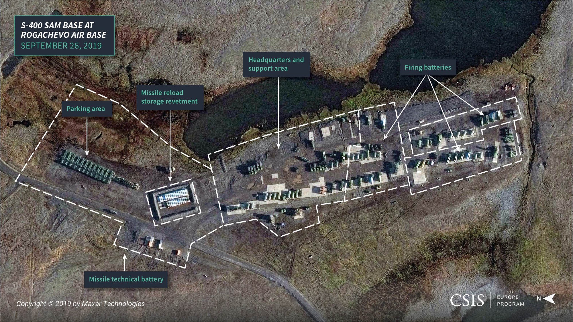
Satellite imagery of Rogachevo shows its S-400 air defense missile base located at 71.606747o N, 52.387603o E, approximately 3.2 km west of the air base. It occupies an irregular shaped area that measures approximately 706-meters-by-180-meters, encompasses approximately 104,600 square meters, and is organized into a regiment-sized unit with:
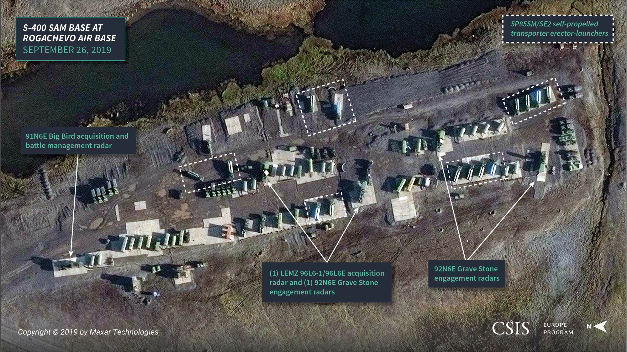
- A headquarters and support area that appears to include the regimental headquarters, target acquisition battery, missile technical battery, transport company, and maintenance company. Among the equipment visible are a number of 55K6E command post vehicles, a 91N6E Big Bird acquisition an d battle management radar, a LEMZ 96L6-1/96L6E acquisition radar, two 5P85SM/SE2 self-propelled transporter erector-launchers (likely as spares or for training), and a number of support vehicles and trailers.
- Three firing battery areas, each with four 5P85SM/ SE2 self-propelled transporter erector-launchers and a single 92N6E Grave Stone engagement radar—all of these are positioned on concrete pads—and a number of support vehicles.11
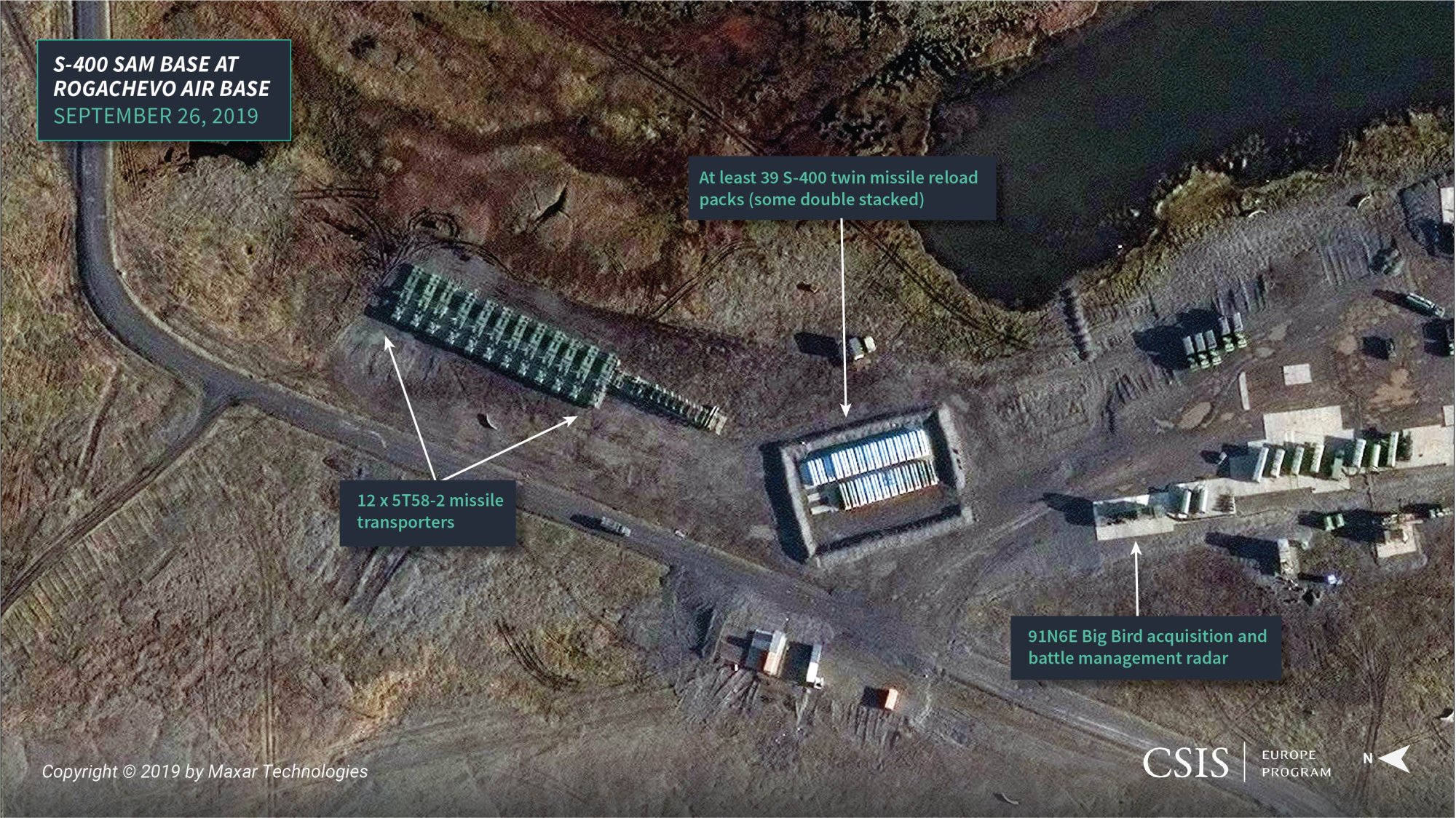
- A 42-meter-by-60-meter missile reloading storage revetment that contains at least 39 S-400 twin missile reload packs (some double-stacked).
- Several support, storage, and parking areas are located around the base. The largest of which is the missile technical battery’s parking area, which contains 12 5T58-2 missile transporters and what may be a number of trailers.